Title:
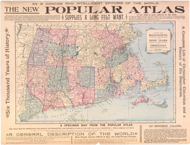
“Map of Massachusetts. Rhode Island. Connecticut”
Map Maker:
Mast, Crowell & Kirkpatrick
This map covers Massachusetts, Rhode Island and Co... (full text available to subscribers)
| Item Detail |
| |
| |
MapMaker: |
Mast, Crowell & Kirkpatrick
|
|
| |
| |
Subject: |
United States - New England |
|
| |
Period/Size: |
1890 / 13.0" x 20.0" (33.1 x 50.8 cm)
|
|
| |
Color: |
Colored
|
|
| |
Condition: |
Nice clean image. There are a few fold separations and small chips confined primarily to the blank margins. (condition help) |
|
| |
Source: |
|
|
| |
References: |
|
|
| |
|
|
| Sales Information |
| |
| |
Price: |
|
|
| |
| |
Offered by: |
Old World Auctions |
|
| |
Catalog: |
Auction No. 137 - Antique Maps, Charts, Atlases & Globes (7408) |
|
| |
Lot/Item #: |
203 |
|
| |
| |
Date: |
09/2011
|
|
| |
| |
|
Antique Maps - Valuation and Pricing, Descriptions, Resources |
|
Home |
Information |
Search |
Register |
Contact Us |
Site Map
Americana Exchange, Inc. © 1999 - 2024 Americana Exchange, Inc.. All rights reserved.
OldMaps.com, the OldMaps.com logo and
AMPR are service marks or registered service marks of Americana Exchange, Inc..
|