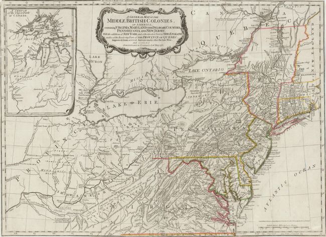
Title:
“A General Map of the Middle British Colonies, in America, containing Virginia, Maryland, the Delaware Counties, Pennsylvania and New Jersey. With the Addition of New York, and of the Greatest Part of New England…”
Map Maker:
Sayer & Bennett
This is a later derivative of the seminal Lewis Ev... (full text available to subscribers)
| Item Detail |
| |
| |
MapMaker: |
Sayer & Bennett
|
|
| |
| |
Subject: |
Colonial Mid-Atlantic |
|
| |
Period/Size: |
1776 / 19.0" x 26.0" (48.3 x 66.1 cm)
|
|
| |
Color: |
Colored
|
|
| |
Condition: |
Old color with a few separations at fold intersections. A few fold separations have been professionally closed on verso, with the exception of a 1" separation near the center of map. Trimmed close to neatline on all sides, and minute loss of neatline in (condition help) |
|
| |
Source: |
American Military Pocket Atlas |
|
| |
References: |
McCorkle #776.10; Sellers & Van Ee #714; Steven & Tree #30-f. |
|
| |
|
|
| Sales Information |
| |
| |
Price: |
|
|
| |
| |
Offered by: |
Old World Auctions |
|
| |
Catalog: |
Auction No. 137 - Antique Maps, Charts, Atlases & Globes (7408) |
|
| |
Lot/Item #: |
207 |
|
| |
| |
Date: |
09/2011
|
|
| |
| |
|
Antique Maps - Valuation and Pricing, Descriptions, Resources |
|
Home |
Information |
Search |
Register |
Contact Us |
Site Map
Americana Exchange, Inc. © 1999 - 2024 Americana Exchange, Inc.. All rights reserved.
OldMaps.com, the OldMaps.com logo and
AMPR are service marks or registered service marks of Americana Exchange, Inc..
|