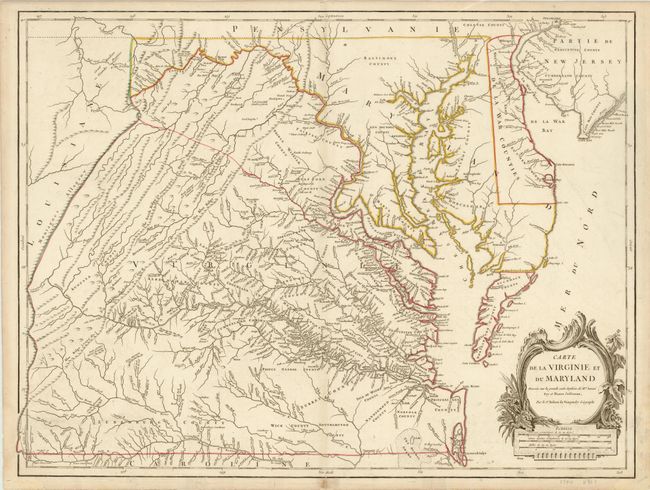
Title:
“Carte de la Virginie et du Maryland Dressee sur la Grande Carte Angloise de Mrs. Josue Fry et Pierre Jefferson…”
Map Maker:
Didier Robert de Vaugondy
This handsome map is the fifth state of Didier Rob... (full text available to subscribers)
| Item Detail |
| |
| |
MapMaker: |
Didier Robert de Vaugondy
|
|
| |
| |
Subject: |
Colonial Mid-Atlantic |
|
| |
Period/Size: |
1793 / 19.3" x 25.5" (49.1 x 64.8 cm)
|
|
| |
Color: |
Colored
|
|
| |
Condition: |
Nice example. There are a few small tears in the lower blank margin and the bottom centerfold has a small separation that just passes the neat line. Light soiling primarily in the blank margins. (condition help) |
|
| |
Source: |
|
|
| |
References: |
cf Cumming (SE) #281; Pedley #470; Phillips, (VA) pp. 49. |
|
| |
|
|
| Sales Information |
| |
| |
Price: |
|
|
| |
| |
Offered by: |
Old World Auctions |
|
| |
Catalog: |
Auction No. 137 - Antique Maps, Charts, Atlases & Globes (7408) |
|
| |
Lot/Item #: |
209 |
|
| |
| |
Date: |
09/2011
|
|
| |
| |
|
Antique Maps - Valuation and Pricing, Descriptions, Resources |
|
Home |
Information |
Search |
Register |
Contact Us |
Site Map
Americana Exchange, Inc. © 1999 - 2024 Americana Exchange, Inc.. All rights reserved.
OldMaps.com, the OldMaps.com logo and
AMPR are service marks or registered service marks of Americana Exchange, Inc..
|