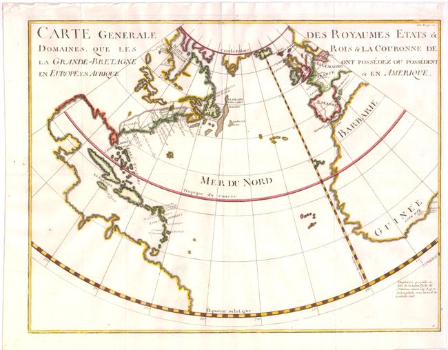
Title:
“Carte Generale des Royaumes Etats & Domaines, que les Rois & La Couronne de la Grande-Bretagne ont Possedez ou Possedent en Europe en Afrique & en Amerique”
Map Maker:
Paul Rapin de Thoyras
This unusual map of the North Atlantic identifies ... (full text available to subscribers)
| Item Detail |
| |
| |
MapMaker: |
Paul Rapin de Thoyras
|
|
| |
| |
Subject: |
Atlantic Ocean |
|
| |
Period/Size: |
1736 / 16.0" x 21.0" (40.7 x 53.4 cm)
|
|
| |
Color: |
Colored
|
|
| |
Condition: |
Issued folding, now pressed. On watermarked paper, with right-hand margin cut within 1/8" of neatline. (condition help) |
|
| |
Source: |
L'Histoire d'Angleterre |
|
| |
References: |
|
|
| |
|
|
| Sales Information |
| |
| |
Price: |
|
|
| |
| |
Offered by: |
Old World Auctions |
|
| |
Catalog: |
Auction No. 137 - Antique Maps, Charts, Atlases & Globes (7408) |
|
| |
Lot/Item #: |
477 |
|
| |
| |
Date: |
09/2011
|
|
| |
| |
|
Antique Maps - Valuation and Pricing, Descriptions, Resources |
|
Home |
Information |
Search |
Register |
Contact Us |
Site Map
Americana Exchange, Inc. © 1999 - 2024 Americana Exchange, Inc.. All rights reserved.
OldMaps.com, the OldMaps.com logo and
AMPR are service marks or registered service marks of Americana Exchange, Inc..
|