Title:
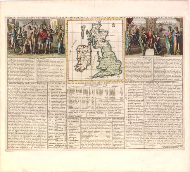
“Carte du Gouvernement Militaire d'Angleterre ou l'on Represente l'Etat des Officiers de Guerre…”
Map Maker:
Henry Abraham Chatelain
An interesting map of the of British Isles (6 x 6.... (full text available to subscribers)
| Item Detail |
| |
| |
MapMaker: |
Henry Abraham Chatelain
|
|
| |
| |
Subject: |
Britain |
|
| |
Period/Size: |
1708 / 13.8" x 18.0" (35.1 x 45.8 cm)
|
|
| |
Color: |
Colored
|
|
| |
Condition: |
Centerfold separation in top blank margin has been closed on verso with archival materials. (condition help) |
|
| |
Source: |
Atlas Historique, ou Nouvelle Introduction a l'Histoire… |
|
| |
References: |
|
|
| |
|
|
| Sales Information |
| |
| |
Price: |
|
|
| |
| |
Offered by: |
Old World Auctions |
|
| |
Catalog: |
Auction No. 137 - Antique Maps, Charts, Atlases & Globes (7408) |
|
| |
Lot/Item #: |
499 |
|
| |
| |
Date: |
09/2011
|
|
| |
| |
|
Antique Maps - Valuation and Pricing, Descriptions, Resources |
|
Home |
Information |
Search |
Register |
Contact Us |
Site Map
Americana Exchange, Inc. © 1999 - 2024 Americana Exchange, Inc.. All rights reserved.
OldMaps.com, the OldMaps.com logo and
AMPR are service marks or registered service marks of Americana Exchange, Inc..
|