Title:
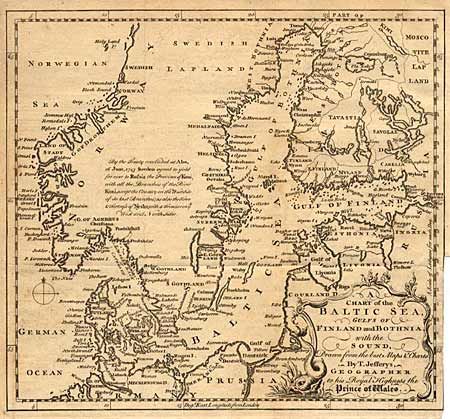
“A Chart of the Baltic Sea, Gulfs of Finland and Bothnia, with the Sound, Drawn from the best Maps & Charts”
Map Maker:
Thomas Jefferys
A finely executed copper engraving depicting the e... (full text available to subscribers)
| Item Detail |
| |
| |
MapMaker: |
Thomas Jefferys
|
|
| |
| |
Subject: |
Baltic |
|
| |
Period/Size: |
1748 / 9.2" x 10.2" (23.4 x 25.9 cm)
|
|
| |
Color: |
Black & White
|
|
| |
Condition: |
(C) Trimmed to neatline at binding side with a short tear. (condition help) |
|
| |
Source: |
|
|
| |
References: |
|
|
| |
|
|
| Sales Information |
| |
| |
Price: |
|
|
| |
| |
Offered by: |
Old World Auctions |
|
| |
Catalog: |
Auction No. 89 - Antique Maps, Charts, Atlases & Globes (161) |
|
| |
Lot/Item #: |
173 |
|
| |
| |
Date: |
12/1999
|
|
| |
| |
|
Antique Maps - Valuation and Pricing, Descriptions, Resources |
|
Home |
Information |
Search |
Register |
Contact Us |
Site Map
Americana Exchange, Inc. © 1999 - 2024 Americana Exchange, Inc.. All rights reserved.
OldMaps.com, the OldMaps.com logo and
AMPR are service marks or registered service marks of Americana Exchange, Inc..
|