Title:
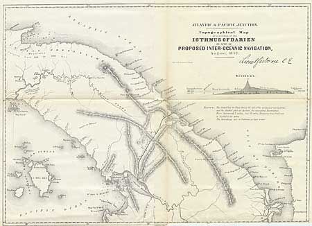
“Atlantic & Pacific Junction - Topographical Map of the portion of the Isthmus of Darien in site of Proposed Inter-Oceanic Navigation, August, 1852”
Map Maker:
U.S. Government
Nice detailed lithographed map showing the site of... (full text available to subscribers)
| Item Detail |
| |
| |
MapMaker: |
U.S. Government
|
|
| |
| |
Subject: |
Panama |
|
| |
Period/Size: |
1854 / 13.5" x 19.1" (34.3 x 48.6 cm)
|
|
| |
Color: |
Black & White
|
|
| |
Condition: |
(B) Trimmed close at binding side with a tiny binding tear affecting the neatline, else fine. (condition help) |
|
| |
Source: |
|
|
| |
References: |
|
|
| |
|
|
| Sales Information |
| |
| |
Price: |
|
|
| |
| |
Offered by: |
Old World Auctions |
|
| |
Catalog: |
Auction No. 91 - Antique Maps, Charts, Atlases & Globes (163) |
|
| |
Lot/Item #: |
181 |
|
| |
| |
Date: |
06/2000
|
|
| |
| |
|
Antique Maps - Valuation and Pricing, Descriptions, Resources |
|
Home |
Information |
Search |
Register |
Contact Us |
Site Map
Americana Exchange, Inc. © 1999 - 2024 Americana Exchange, Inc.. All rights reserved.
OldMaps.com, the OldMaps.com logo and
AMPR are service marks or registered service marks of Americana Exchange, Inc..
|