Title:
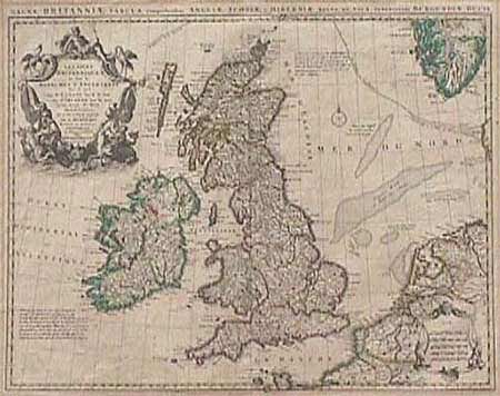
“Les Isles Britanniques ou sont le Royaumes d'Angleterre…”
Map Maker:
Guillaume Delisle
Striking map of the British Isles with De l'Isle's... (full text available to subscribers)
| Item Detail |
| |
| |
MapMaker: |
Guillaume Delisle
|
|
| |
| |
Subject: |
Britain |
|
| |
Period/Size: |
1738 / 18.2" x 22.5" (46.3 x 57.2 cm)
|
|
| |
Color: |
Colored
|
|
| |
Condition: |
(B) Mat burn in margins and on verso with remnants of masking tape on verso where it was previously mounted. The map image itself is generally clean and the engraving is very crisp. (condition help) |
|
| |
Source: |
|
|
| |
References: |
|
|
| |
|
|
| Sales Information |
| |
| |
Price: |
|
|
| |
| |
Offered by: |
Old World Auctions |
|
| |
Catalog: |
Auction No. 91 - Antique Maps, Charts, Atlases & Globes (163) |
|
| |
Lot/Item #: |
219 |
|
| |
| |
Date: |
06/2000
|
|
| |
| |
|
Antique Maps - Valuation and Pricing, Descriptions, Resources |
|
Home |
Information |
Search |
Register |
Contact Us |
Site Map
Americana Exchange, Inc. © 1999 - 2024 Americana Exchange, Inc.. All rights reserved.
OldMaps.com, the OldMaps.com logo and
AMPR are service marks or registered service marks of Americana Exchange, Inc..
|