Title:
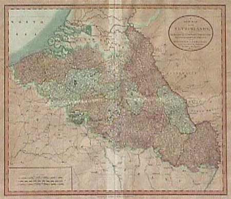
“A New Map of the Netherlands, also of that part of Germany Westward of the Rhine as ceded to the French and Divided into their several Departments from the Latest Authorities”
Map Maker:
George Cary
Covers the region of modern day Belguim and Luxemb... (full text available to subscribers)
| Item Detail |
| |
| |
MapMaker: |
George Cary
|
|
| |
| |
Subject: |
Netherlands, Belgium and Luxemborg |
|
| |
Period/Size: |
1804 / 17.7" x 20.0" (45.0 x 50.8 cm)
|
|
| |
Color: |
Colored
|
|
| |
Condition: |
(B) Acid-burned on verso and toned throughout. (condition help) |
|
| |
Source: |
|
|
| |
References: |
|
|
| |
|
|
| Sales Information |
| |
| |
Price: |
|
|
| |
| |
Offered by: |
Old World Auctions |
|
| |
Catalog: |
Auction No. 91 - Antique Maps, Charts, Atlases & Globes (163) |
|
| |
Lot/Item #: |
249 |
|
| |
| |
Date: |
06/2000
|
|
| |
| |
|
Antique Maps - Valuation and Pricing, Descriptions, Resources |
|
Home |
Information |
Search |
Register |
Contact Us |
Site Map
Americana Exchange, Inc. © 1999 - 2024 Americana Exchange, Inc.. All rights reserved.
OldMaps.com, the OldMaps.com logo and
AMPR are service marks or registered service marks of Americana Exchange, Inc..
|