Title:
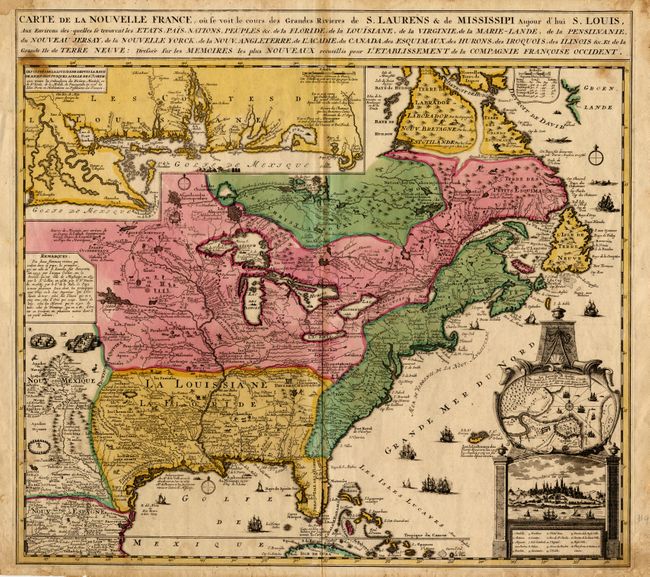
“Carte de la Nouvelle France, ou se voit le cours des Grandes Rivieres de S. Laurens & de Mississipi aujour d'hui S. Louis, Aux Environs desquelles se trouvent les Etats, Pays, Nations, Peuples & c…”
Map Maker:
Nicolas de Fer
A one sheet version of the Nicholas De Fer's four-... (full text available to subscribers)
| Item Detail |
| |
| |
MapMaker: |
Nicolas de Fer
|
|
| |
| |
Subject: |
Colonial North America |
|
| |
Period/Size: |
1719 / 19.5" x 22.5" (49.6 x 57.2 cm)
|
|
| |
Color: |
Colored
|
|
| |
Condition: |
(A) Manuscript ink on verso listing the 13 colonies with their populations, dated 1783. A few minor spots affecting title and top border and a bit of toning along fold. (condition help) |
|
| |
Source: |
|
|
| |
References: |
|
|
| |
|
|
| Sales Information |
| |
| |
Price: |
|
|
| |
| |
Offered by: |
Old World Auctions |
|
| |
Catalog: |
Auction No. 91 - Antique Maps, Charts, Atlases & Globes (163) |
|
| |
Lot/Item #: |
108 |
|
| |
| |
Date: |
06/2000
|
|
| |
| |
|
Antique Maps - Valuation and Pricing, Descriptions, Resources |
|
Home |
Information |
Search |
Register |
Contact Us |
Site Map
Americana Exchange, Inc. © 1999 - 2024 Americana Exchange, Inc.. All rights reserved.
OldMaps.com, the OldMaps.com logo and
AMPR are service marks or registered service marks of Americana Exchange, Inc..
|