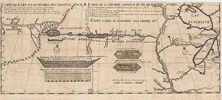
Title:
“Carte que les Gnacsitares ont Dessine…Carte de la Riviere Longue et de Quelques Autres…”
Map Maker:
Louis Armand de Lom d'Arce, de Lahontan
One of the most influential, and fanciful, maps in... (full text available to subscribers)
| Item Detail |
| |
| |
MapMaker: |
Louis Armand de Lom d'Arce, de Lahontan
|
|
| |
| |
Subject: |
Colonial United States |
|
| |
Period/Size: |
1703 / 11.0" x 26.3" (28.0 x 66.7 cm)
|
|
| |
Color: |
Black & White
|
|
| |
Condition: |
(A+) Very minor offsetting, still fine. (condition help) |
|
| |
Source: |
|
|
| |
References: |
Schwartz and Ehrenberg #81; Kershaw #298; Verner & Stuart Stubbs #20. |
|
| |
|
|
| Sales Information |
| |
| |
Price: |
|
|
| |
| |
Offered by: |
Old World Auctions |
|
| |
Catalog: |
Auction No. 91 - Antique Maps, Charts, Atlases & Globes (163) |
|
| |
Lot/Item #: |
116 |
|
| |
| |
Date: |
06/2000
|
|
| |
| |
|
Antique Maps - Valuation and Pricing, Descriptions, Resources |
|
Home |
Information |
Search |
Register |
Contact Us |
Site Map
Americana Exchange, Inc. © 1999 - 2024 Americana Exchange, Inc.. All rights reserved.
OldMaps.com, the OldMaps.com logo and
AMPR are service marks or registered service marks of Americana Exchange, Inc..
|