Title:
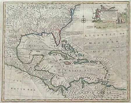
“An Accurate Map of the West Indies Drawn form the best Authorities…”
Map Maker:
John T. Bowen & Co.
Attractive copper engraved map covering the southe... (full text available to subscribers)
| Item Detail |
| |
| |
MapMaker: |
John T. Bowen & Co.
|
|
| |
| |
Subject: |
Colonial United States and West Indies |
|
| |
Period/Size: |
1763 / 13.5" x 16.5" (34.3 x 42.0 cm)
|
|
| |
Color: |
Colored
|
|
| |
Condition: |
(A) Folding as issued and now pressed. Later color which is incomplete, else fine. (condition help) |
|
| |
Source: |
|
|
| |
References: |
|
|
| |
|
|
| Sales Information |
| |
| |
Price: |
|
|
| |
| |
Offered by: |
Old World Auctions |
|
| |
Catalog: |
Auction No. 91 - Antique Maps, Charts, Atlases & Globes (163) |
|
| |
Lot/Item #: |
177 |
|
| |
| |
Date: |
06/2000
|
|
| |
| |
|
Antique Maps - Valuation and Pricing, Descriptions, Resources |
|
Home |
Information |
Search |
Register |
Contact Us |
Site Map
Americana Exchange, Inc. © 1999 - 2024 Americana Exchange, Inc.. All rights reserved.
OldMaps.com, the OldMaps.com logo and
AMPR are service marks or registered service marks of Americana Exchange, Inc..
|