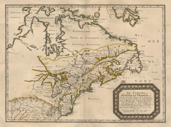
Title:
“Le Canada, ou Nouvelle France, &c…”
Map Maker:
Nicolas Sanson
One of the most influential 17th century maps of e... (full text available to subscribers)
| Item Detail |
| |
| |
MapMaker: |
Nicolas Sanson
|
|
| |
| |
Subject: |
Colonial United States and Canada |
|
| |
Period/Size: |
1656 / 15.7" x 21.5" (39.9 x 54.7 cm)
|
|
| |
Color: |
Colored
|
|
| |
Condition: |
(A+) Trimmed to just outside neatline and mounted on a larger sheet of fine 17th or early 18th century paper for binding into a composite atlas (a common practice at the time). Superb impression and color. (condition help) |
|
| |
Source: |
|
|
| |
References: |
Burden #318; Kershaw #81. |
|
| |
|
|
| Sales Information |
| |
| |
Price: |
|
|
| |
| |
Offered by: |
Old World Auctions |
|
| |
Catalog: |
Auction No. 92 - Antique Maps, Charts, Atlases & Globes (164) |
|
| |
Lot/Item #: |
114 |
|
| |
| |
Date: |
09/2000
|
|
| |
| |
|
Antique Maps - Valuation and Pricing, Descriptions, Resources |
|
Home |
Information |
Search |
Register |
Contact Us |
Site Map
Americana Exchange, Inc. © 1999 - 2024 Americana Exchange, Inc.. All rights reserved.
OldMaps.com, the OldMaps.com logo and
AMPR are service marks or registered service marks of Americana Exchange, Inc..
|