Title:
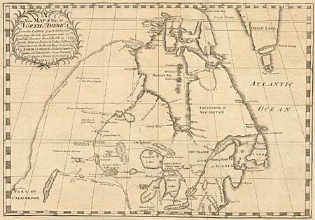
“A new Map of Part of North America From the Latitude of 40 to 68 Degrees. Including the late discoveries made on Board the Furnace Bomb Ketch in 1742…”
Map Maker:
Joseph La France
A scarce and significant map illustrating the cont... (full text available to subscribers)
| Item Detail |
| |
| |
MapMaker: |
Joseph La France
|
|
| |
| |
Subject: |
Canada |
|
| |
Period/Size: |
1744 / 13.0" x 19.0" (33.1 x 48.3 cm)
|
|
| |
Color: |
Black & White
|
|
| |
Condition: |
(A) Issued folded and now pressed flat with fold intersections reinforced with Japanese tissue. Tiny puncture also professionally repaired. (condition help) |
|
| |
Source: |
|
|
| |
References: |
Verner & Stuart-Stubbs #21; Kershaw #422. |
|
| |
|
|
| Sales Information |
| |
| |
Price: |
|
|
| |
| |
Offered by: |
Old World Auctions |
|
| |
Catalog: |
Auction No. 92 - Antique Maps, Charts, Atlases & Globes (164) |
|
| |
Lot/Item #: |
101 |
|
| |
| |
Date: |
09/2000
|
|
| |
| |
|
Antique Maps - Valuation and Pricing, Descriptions, Resources |
|
Home |
Information |
Search |
Register |
Contact Us |
Site Map
Americana Exchange, Inc. © 1999 - 2024 Americana Exchange, Inc.. All rights reserved.
OldMaps.com, the OldMaps.com logo and
AMPR are service marks or registered service marks of Americana Exchange, Inc..
|