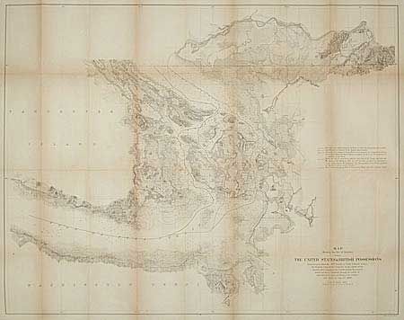
Title:
“Map showing the line of Boundary between the United States and British Possessions”
Map Maker:
John T. Bowen & Co.
The map shows three contemplated boundaries and th... (full text available to subscribers)
| Item Detail |
| |
| |
MapMaker: |
John T. Bowen & Co.
|
|
| |
| |
Subject: |
United States and Canada |
|
| |
Period/Size: |
1872 / 28.2" x 36.3" (71.7 x 92.2 cm)
|
|
| |
Color: |
Black & White
|
|
| |
Condition: |
(B) Backed with Japanese tissue, toned at folds. (condition help) |
|
| |
Source: |
|
|
| |
References: |
|
|
| |
|
|
| Sales Information |
| |
| |
Price: |
|
|
| |
| |
Offered by: |
Old World Auctions |
|
| |
Catalog: |
Auction No. 93 - Antique Maps, Charts, Atlases & Globes (165) |
|
| |
Lot/Item #: |
105 |
|
| |
| |
Date: |
12/2000
|
|
| |
| |
|
Antique Maps - Valuation and Pricing, Descriptions, Resources |
|
Home |
Information |
Search |
Register |
Contact Us |
Site Map
Americana Exchange, Inc. © 1999 - 2024 Americana Exchange, Inc.. All rights reserved.
OldMaps.com, the OldMaps.com logo and
AMPR are service marks or registered service marks of Americana Exchange, Inc..
|