Title:
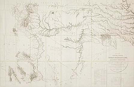
“Map of the United States and Texas Boundary Line and Adjacent Territory determined & surveyed 1857”
Map Maker:
U.S. Geological Survey
By J.H. Clark, U.S. Commissioner, drawn by J.E. We... (full text available to subscribers)
| Item Detail |
| |
| |
MapMaker: |
U.S. Geological Survey
|
|
| |
| |
Subject: |
Texas |
|
| |
Period/Size: |
1902 / 26.2" x 39.5" (66.6 x 100.4 cm)
|
|
| |
Color: |
Black & White
|
|
| |
Condition: |
(A) Folding as issued. (condition help) |
|
| |
Source: |
|
|
| |
References: |
Wheat [TMW] #1022. |
|
| |
|
|
| Sales Information |
| |
| |
Price: |
|
|
| |
| |
Offered by: |
Old World Auctions |
|
| |
Catalog: |
Auction No. 93 - Antique Maps, Charts, Atlases & Globes (165) |
|
| |
Lot/Item #: |
150 |
|
| |
| |
Date: |
12/2000
|
|
| |
| |
|
Antique Maps - Valuation and Pricing, Descriptions, Resources |
|
Home |
Information |
Search |
Register |
Contact Us |
Site Map
Americana Exchange, Inc. © 1999 - 2024 Americana Exchange, Inc.. All rights reserved.
OldMaps.com, the OldMaps.com logo and
AMPR are service marks or registered service marks of Americana Exchange, Inc..
|