Title:
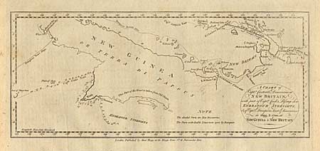
“A Chart of Capt.n Carteret's Discoveries at New Britain, with part of Capt.n Cook's Passage thro Endeavour Streights, & of Capt.n Dampier's Tract & Discoveries in 1699, & 1700, at New Guinea & New Britain”
Map Maker:
Cook/Hogg
Detailed chart with new discoveries shown shaded. ... (full text available to subscribers)
| Item Detail |
| |
| |
MapMaker: |
Cook/Hogg
|
|
| |
| |
Subject: |
Papua New Guinea |
|
| |
Period/Size: |
1784 / 6.0" x 14.1" (15.3 x 35.9 cm)
|
|
| |
Color: |
Black & White
|
|
| |
Condition: |
(A) (condition help) |
|
| |
Source: |
|
|
| |
References: |
|
|
| |
|
|
| Sales Information |
| |
| |
Price: |
|
|
| |
| |
Offered by: |
Old World Auctions |
|
| |
Catalog: |
Auction No. 93 - Antique Maps, Charts, Atlases & Globes (165) |
|
| |
Lot/Item #: |
334 |
|
| |
| |
Date: |
12/2000
|
|
| |
| |
|
Antique Maps - Valuation and Pricing, Descriptions, Resources |
|
Home |
Information |
Search |
Register |
Contact Us |
Site Map
Americana Exchange, Inc. © 1999 - 2024 Americana Exchange, Inc.. All rights reserved.
OldMaps.com, the OldMaps.com logo and
AMPR are service marks or registered service marks of Americana Exchange, Inc..
|