Title:
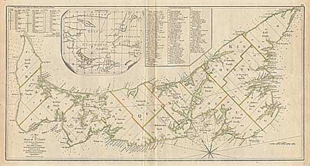
“A Map of the Island of St. John in the Gulf of St. Laurence Divided Into Counties & Parishes and the Lots, as Granted by Government…”
Map Maker:
Sayer & Bennett
First state of this fascinating plat map of the is... (full text available to subscribers)
| Item Detail |
| |
| |
MapMaker: |
Sayer & Bennett
|
|
| |
| |
Subject: |
Canada |
|
| |
Period/Size: |
1775 / 14.2" x 27.5" (36.1 x 69.9 cm)
|
|
| |
Color: |
Colored
|
|
| |
Condition: |
(A) Faint toning along centerfold and short fold separation in bottom margin, else fine. (condition help) |
|
| |
Source: |
|
|
| |
References: |
Kershaw #844 |
|
| |
|
|
| Sales Information |
| |
| |
Price: |
|
|
| |
| |
Offered by: |
Old World Auctions |
|
| |
Catalog: |
Auction No. 93 - Antique Maps, Charts, Atlases & Globes (165) |
|
| |
Lot/Item #: |
102 |
|
| |
| |
Date: |
12/2000
|
|
| |
| |
|
Antique Maps - Valuation and Pricing, Descriptions, Resources |
|
Home |
Information |
Search |
Register |
Contact Us |
Site Map
Americana Exchange, Inc. © 1999 - 2024 Americana Exchange, Inc.. All rights reserved.
OldMaps.com, the OldMaps.com logo and
AMPR are service marks or registered service marks of Americana Exchange, Inc..
|