Title:
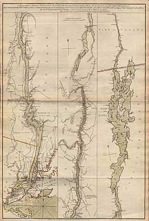
“A Topographical Map of Hudson's River … from Sandy-Hook … to Fort Edward, also the Communication with Canada by Lake George and Lake Champlain, as high as Fort Chambly on Sorel River”
Map Maker:
Sauthier/Faden
Important REVOLUTIONARY WAR period map showing the... (full text available to subscribers)
| Item Detail |
| |
| |
MapMaker: |
Sauthier/Faden
|
|
| |
| |
Subject: |
Colonial America - New York |
|
| |
Period/Size: |
1776 / 31.0" x 20.7" (78.8 x 52.6 cm)
|
|
| |
Color: |
Colored
|
|
| |
Condition: |
(A+) (condition help) |
|
| |
Source: |
|
|
| |
References: |
Sellers and van Ee #1069, Tooley #23c, p. |
|
| |
|
|
| Sales Information |
| |
| |
Price: |
|
|
| |
| |
Offered by: |
Old World Auctions |
|
| |
Catalog: |
Auction No. 94 - Antique Maps, Charts, Atlases & Globes (166) |
|
| |
Lot/Item #: |
96 |
|
| |
| |
Date: |
03/2001
|
|
| |
| |
|
Antique Maps - Valuation and Pricing, Descriptions, Resources |
|
Home |
Information |
Search |
Register |
Contact Us |
Site Map
Americana Exchange, Inc. © 1999 - 2024 Americana Exchange, Inc.. All rights reserved.
OldMaps.com, the OldMaps.com logo and
AMPR are service marks or registered service marks of Americana Exchange, Inc..
|