Title:
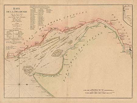
“Bay de la Delaware Avec les Ports, Sondes, Dangers, Bancs. &c. depuis les Caps, Jusqu'q Philadelphie de'Apres la Carte de Joshua Fisher publiee a Philadelphie”
Map Maker:
George Louis Le Rouge
This is a French version of Joshua Fisher’s detail... (full text available to subscribers)
| Item Detail |
| |
| |
MapMaker: |
George Louis Le Rouge
|
|
| |
| |
Subject: |
Colonial America |
|
| |
Period/Size: |
1777 / 18.2" x 25.0" (46.3 x 63.5 cm)
|
|
| |
Color: |
Colored
|
|
| |
Condition: |
(A+) Expert and invisible repair of some tiny tears in margins, all well away from the map. (condition help) |
|
| |
Source: |
|
|
| |
References: |
Sellers and Van Ee #1357. |
|
| |
|
|
| Sales Information |
| |
| |
Price: |
|
|
| |
| |
Offered by: |
Old World Auctions |
|
| |
Catalog: |
Auction No. 94 - Antique Maps, Charts, Atlases & Globes (166) |
|
| |
Lot/Item #: |
98 |
|
| |
| |
Date: |
03/2001
|
|
| |
| |
|
Antique Maps - Valuation and Pricing, Descriptions, Resources |
|
Home |
Information |
Search |
Register |
Contact Us |
Site Map
Americana Exchange, Inc. © 1999 - 2024 Americana Exchange, Inc.. All rights reserved.
OldMaps.com, the OldMaps.com logo and
AMPR are service marks or registered service marks of Americana Exchange, Inc..
|