Title:
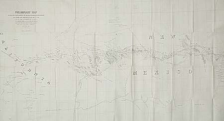
“Preliminary Map of the Western Portion of the Reconnaissance and Survey for a Pacific Railroad Route near the 35th Par. Made by Capt. A.W. Whipple T.E. in 1853-4…”
Map Maker:
Amiel Weekes Whipple
Large lithographed map covering from Albuquerque t... (full text available to subscribers)
| Item Detail |
| |
| |
MapMaker: |
Amiel Weekes Whipple
|
|
| |
| |
Subject: |
New Mexico |
|
| |
Period/Size: |
1857-8 / 26.2" x 48.7" (66.6 x 123.7 cm)
|
|
| |
Color: |
Black & White
|
|
| |
Condition: |
(B) Closely trimmed at both sides affecting neatlines, as issued. (condition help) |
|
| |
Source: |
|
|
| |
References: |
Wheat (TMW) 939. |
|
| |
|
|
| Sales Information |
| |
| |
Price: |
|
|
| |
| |
Offered by: |
Old World Auctions |
|
| |
Catalog: |
Auction No. 94 - Antique Maps, Charts, Atlases & Globes (166) |
|
| |
Lot/Item #: |
126 |
|
| |
| |
Date: |
03/2001
|
|
| |
| |
|
Antique Maps - Valuation and Pricing, Descriptions, Resources |
|
Home |
Information |
Search |
Register |
Contact Us |
Site Map
Americana Exchange, Inc. © 1999 - 2024 Americana Exchange, Inc.. All rights reserved.
OldMaps.com, the OldMaps.com logo and
AMPR are service marks or registered service marks of Americana Exchange, Inc..
|