Title:
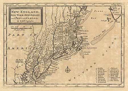
“New England, New York, New Jersey, and Pensilvania &c.”
Map Maker:
Herman Moll
Herman Moll's earliest map of New England. New Yo... (full text available to subscribers)
| Item Detail |
| |
| |
MapMaker: |
Herman Moll
|
|
| |
| |
Subject: |
Colonial United States |
|
| |
Period/Size: |
1708 / 7.0" x 10.2" (17.8 x 25.9 cm)
|
|
| |
Color: |
Black & White
|
|
| |
Condition: |
(A) Crisp impression with slightly uneven toning. (condition help) |
|
| |
Source: |
|
|
| |
References: |
|
|
| |
|
|
| Sales Information |
| |
| |
Price: |
|
|
| |
| |
Offered by: |
Old World Auctions |
|
| |
Catalog: |
Auction No. 89 - Antique Maps, Charts, Atlases & Globes (161) |
|
| |
Lot/Item #: |
76 |
|
| |
| |
Date: |
12/1999
|
|
| |
| |
|
Antique Maps - Valuation and Pricing, Descriptions, Resources |
|
Home |
Information |
Search |
Register |
Contact Us |
Site Map
Americana Exchange, Inc. © 1999 - 2024 Americana Exchange, Inc.. All rights reserved.
OldMaps.com, the OldMaps.com logo and
AMPR are service marks or registered service marks of Americana Exchange, Inc..
|