Title:
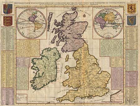
“Nouvelle Carte d' Angleterre, d' Ecosse, et d' Irlande, avec des Instructions pour connoitre les differents etats”
Map Maker:
Henry Abraham Chatelain
Impressive map of the British Isles with insets of... (full text available to subscribers)
| Item Detail |
| |
| |
MapMaker: |
Henry Abraham Chatelain
|
|
| |
| |
Subject: |
Britain |
|
| |
Period/Size: |
1719 / 18.5" x 24.5" (47.0 x 62.3 cm)
|
|
| |
Color: |
Colored
|
|
| |
Condition: |
(A) Very lovely later color. Short separation of fold in margin, repaired with archival tape. (condition help) |
|
| |
Source: |
|
|
| |
References: |
|
|
| |
|
|
| Sales Information |
| |
| |
Price: |
|
|
| |
| |
Offered by: |
Old World Auctions |
|
| |
Catalog: |
Auction No. 94 - Antique Maps, Charts, Atlases & Globes (166) |
|
| |
Lot/Item #: |
232 |
|
| |
| |
Date: |
03/2001
|
|
| |
| |
|
Antique Maps - Valuation and Pricing, Descriptions, Resources |
|
Home |
Information |
Search |
Register |
Contact Us |
Site Map
Americana Exchange, Inc. © 1999 - 2024 Americana Exchange, Inc.. All rights reserved.
OldMaps.com, the OldMaps.com logo and
AMPR are service marks or registered service marks of Americana Exchange, Inc..
|