Title:
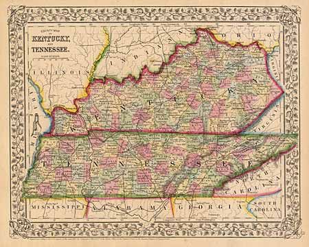
“County Map of Kentucky and Tennessee”
Map Maker:
Samuel Augustus Mitchell
Although many counties were formed by 1800, both s... (full text available to subscribers)
| Item Detail |
| |
| |
MapMaker: |
Samuel Augustus Mitchell
|
|
| |
| |
Subject: |
Kentucky and Tennessee |
|
| |
Period/Size: |
1867 / 10.5" x 13.2" (26.7 x 33.6 cm)
|
|
| |
Color: |
Colored
|
|
| |
Condition: |
(A+) Good impression and detail throughout. (condition help) |
|
| |
Source: |
|
|
| |
References: |
|
|
| |
|
|
| Sales Information |
| |
| |
Price: |
|
|
| |
| |
Offered by: |
Old World Auctions |
|
| |
Catalog: |
Auction No. 90 - Antique Maps, Charts, Atlases & Globes (162) |
|
| |
Lot/Item #: |
115 |
|
| |
| |
Date: |
03/2000
|
|
| |
| |
|
Antique Maps - Valuation and Pricing, Descriptions, Resources |
|
Home |
Information |
Search |
Register |
Contact Us |
Site Map
Americana Exchange, Inc. © 1999 - 2024 Americana Exchange, Inc.. All rights reserved.
OldMaps.com, the OldMaps.com logo and
AMPR are service marks or registered service marks of Americana Exchange, Inc..
|