Title:
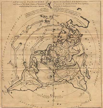
“A Physical Planisphere wherein are represented all the known Lands and Seas in the Great Chains of Mountains w'ch traverse the Globe, from the North Pole adapted to Mons. Buache's Memoire”
Map Maker:
Anonymous
The map depicts Buache's famous north polar projec... (full text available to subscribers)
| Item Detail |
| |
| |
MapMaker: |
Anonymous
|
|
| |
| |
Subject: |
North Pole |
|
| |
Period/Size: |
1757 / 11.5" x 12.2" (29.3 x 31.0 cm)
|
|
| |
Color: |
Black & White
|
|
| |
Condition: |
(C) Evenly toned and trimmed into engraver's signature at bottom with small splits on folds. (condition help) |
|
| |
Source: |
Gentleman's Magazine |
|
| |
References: |
Jolly GENT-104. |
|
| |
|
|
| Sales Information |
| |
| |
Price: |
|
|
| |
| |
Offered by: |
Old World Auctions |
|
| |
Catalog: |
Auction No. 90 - Antique Maps, Charts, Atlases & Globes (162) |
|
| |
Lot/Item #: |
45 |
|
| |
| |
Date: |
03/2000
|
|
| |
| |
|
Antique Maps - Valuation and Pricing, Descriptions, Resources |
|
Home |
Information |
Search |
Register |
Contact Us |
Site Map
Americana Exchange, Inc. © 1999 - 2024 Americana Exchange, Inc.. All rights reserved.
OldMaps.com, the OldMaps.com logo and
AMPR are service marks or registered service marks of Americana Exchange, Inc..
|