Title:
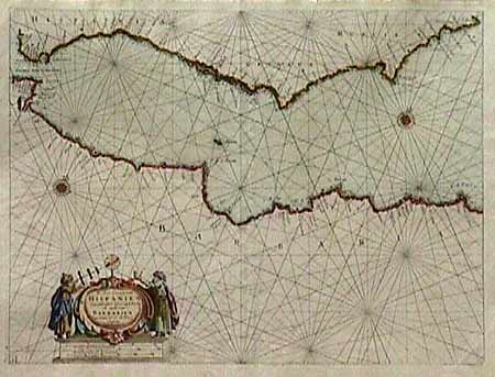
“de Zee Custen van Hispanien van Gibralter tot Caep S. Martin als mede van Barbarien van Seute tot C. Tenes”
Map Maker:
Henrick Doncker
Very fine sea chart of the Strait of Gibraltar and... (full text available to subscribers)
| Item Detail |
| |
| |
MapMaker: |
Henrick Doncker
|
|
| |
| |
Subject: |
Mediterranean |
|
| |
Period/Size: |
1669 / 15.5" x 20.0" (39.4 x 50.8 cm)
|
|
| |
Color: |
Colored
|
|
| |
Condition: |
(A+) On fine thick paper with a crisp impression. (condition help) |
|
| |
Source: |
|
|
| |
References: |
|
|
| |
|
|
| Sales Information |
| |
| |
Price: |
|
|
| |
| |
Offered by: |
Old World Auctions |
|
| |
Catalog: |
Auction No. 88 - Antique Maps, Charts, Atlases & Globes (160) |
|
| |
Lot/Item #: |
270 |
|
| |
| |
Date: |
10/1999
|
|
| |
| |
|
Antique Maps - Valuation and Pricing, Descriptions, Resources |
|
Home |
Information |
Search |
Register |
Contact Us |
Site Map
Americana Exchange, Inc. © 1999 - 2024 Americana Exchange, Inc.. All rights reserved.
OldMaps.com, the OldMaps.com logo and
AMPR are service marks or registered service marks of Americana Exchange, Inc..
|