Title:
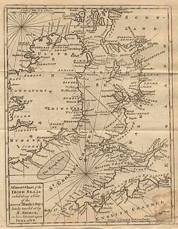
“A Correct Chart of the Irish Sea, &c exhibiting a View of the several Islands and Bays lately touch'd at by M. Thurot, in his Attempt upon Ireland”
Map Maker:
John Gibson
Nice sea chart of the region with detail along coa... (full text available to subscribers)
| Item Detail |
| |
| |
MapMaker: |
John Gibson
|
|
| |
| |
Subject: |
Britain |
|
| |
Period/Size: |
1760 / 9.2" x 7.0" (23.4 x 17.8 cm)
|
|
| |
Color: |
Black & White
|
|
| |
Condition: |
(B) Light stain in bottom right., else very crisp and attractive engraving. (condition help) |
|
| |
Source: |
Gentleman's Magazine |
|
| |
References: |
Jolly GENT-139. |
|
| |
|
|
| Sales Information |
| |
| |
Price: |
|
|
| |
| |
Offered by: |
Old World Auctions |
|
| |
Catalog: |
Auction No. 88 - Antique Maps, Charts, Atlases & Globes (160) |
|
| |
Lot/Item #: |
188 |
|
| |
| |
Date: |
10/1999
|
|
| |
| |
|
Antique Maps - Valuation and Pricing, Descriptions, Resources |
|
Home |
Information |
Search |
Register |
Contact Us |
Site Map
Americana Exchange, Inc. © 1999 - 2024 Americana Exchange, Inc.. All rights reserved.
OldMaps.com, the OldMaps.com logo and
AMPR are service marks or registered service marks of Americana Exchange, Inc..
|