Rister or Sign In to see pricing information


Title:

A Chart of the Pacific Ocean from the Equinoctial to the Latitude of 39 1/2 deg. No.

Map Maker:

Richard William Seale

A Chart of the Pacific Ocean from the Equinoctial to the Latitude of 39 1/2 deg. No.

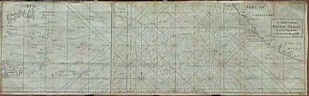
Unusual chart detailing the route of Spanish galle... (full text available to subscribers)
Item Detail
 
  MapMaker:  

Richard William Seale


  Subject:  Pacific Ocean  
  Period/Size:  1750 / 11.0" x 34.7"  (28.0 x 88.2 cm)  
  Color:  Black & White  
  Condition:  (B) Folding, as issued. Lightly toned with a little, barely noticeable, light foxing. Short binding tear with old repair. (condition help)  
  Source:   
  References:  Mercator's World Nov/Dec '98 p.  
 
 
Sales Information
 
  Price: 

Please register your email to view records, or sign in with email address to see records


  Offered by:  Old World Auctions  
  Catalog:  Auction No. 88 - Antique Maps, Charts, Atlases & Globes (160)  
  Lot/Item #:  342  
 
  Date:  10/1999  


Antique Maps - Valuation and Pricing, Descriptions, Resources


Home | Information | Search | Register | Contact Us | Site Map

Americana Exchange, Inc. © 1999 - 2024 Americana Exchange, Inc.. All rights reserved. OldMaps.com, the OldMaps.com logo and
AMPR are service marks or registered service marks of Americana Exchange, Inc..