Title:
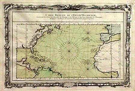
“Carte Reduite de l'Ocean Occidental, Contenant les Cotes Occidentales de l'Europe et de l'Afrique et les Cotes Orientales de l'Amerique…”
Map Maker:
Louis Charles Desnos
Beautifully engraved chart of the Atlantic, north ... (full text available to subscribers)
| Item Detail |
| |
| |
MapMaker: |
Louis Charles Desnos
|
|
| |
| |
Subject: |
Atlantic |
|
| |
Period/Size: |
1761 / 14.0" x 20.2" (35.6 x 51.3 cm)
|
|
| |
Color: |
Colored
|
|
| |
Condition: |
(A) Tiny bit of foxing mostly in margins and not at all distracting. (condition help) |
|
| |
Source: |
|
|
| |
References: |
|
|
| |
|
|
| Sales Information |
| |
| |
Price: |
|
|
| |
| |
Offered by: |
Old World Auctions |
|
| |
Catalog: |
Auction No. 88 - Antique Maps, Charts, Atlases & Globes (160) |
|
| |
Lot/Item #: |
165 |
|
| |
| |
Date: |
10/1999
|
|
| |
| |
|
Antique Maps - Valuation and Pricing, Descriptions, Resources |
|
Home |
Information |
Search |
Register |
Contact Us |
Site Map
Americana Exchange, Inc. © 1999 - 2024 Americana Exchange, Inc.. All rights reserved.
OldMaps.com, the OldMaps.com logo and
AMPR are service marks or registered service marks of Americana Exchange, Inc..
|