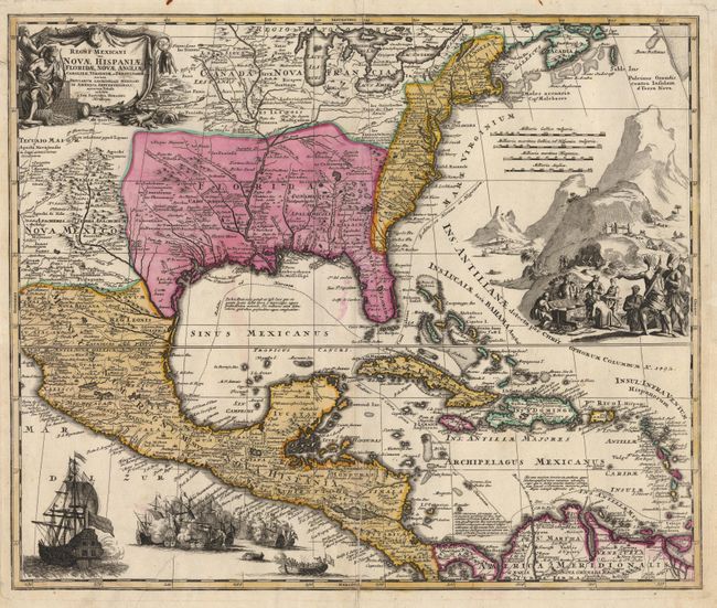
Title:
“Regni Mexicani seu Novae Hispaniae, Ludovicianae, N. Angliae, Carolinae, Virginiae, et Pensylvaniae”
Map Maker:
Johann Baptist Homann
Magnificent, decorative map covering from the Grea... (full text available to subscribers)
| Item Detail |
| |
| |
MapMaker: |
Johann Baptist Homann
|
|
| |
| |
Subject: |
United States, Mexico and West Indies |
|
| |
Period/Size: |
1725 / 18.7" x 22.5" (47.5 x 57.2 cm)
|
|
| |
Color: |
Colored
|
|
| |
Condition: |
(A) Professionally backed with Japanese tissue, closing a tear that entered the map near the sea battle. Very crisp impression with printer's crease near bottom centerfold. (condition help) |
|
| |
Source: |
|
|
| |
References: |
Van Ermen p.42, Cumming (Southeast) #137, Martin & Martin plt.17. |
|
| |
|
|
| Sales Information |
| |
| |
Price: |
|
|
| |
| |
Offered by: |
Old World Auctions |
|
| |
Catalog: |
Auction No. 88 - Antique Maps, Charts, Atlases & Globes (160) |
|
| |
Lot/Item #: |
140 |
|
| |
| |
Date: |
10/1999
|
|
| |
| |
|
Antique Maps - Valuation and Pricing, Descriptions, Resources |
|
Home |
Information |
Search |
Register |
Contact Us |
Site Map
Americana Exchange, Inc. © 1999 - 2024 Americana Exchange, Inc.. All rights reserved.
OldMaps.com, the OldMaps.com logo and
AMPR are service marks or registered service marks of Americana Exchange, Inc..
|