Title:
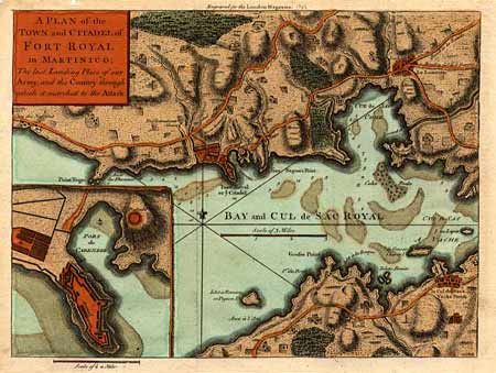
“A Plan of the Town and Citadel of Fort Royal in Martinico; The last Landing Place of our Army, and the Country through which it marched to the Attack”
Map Maker:
Anonymous
Great detailed map of the bay and surrounding fort... (full text available to subscribers)
| Item Detail |
| |
| |
MapMaker: |
Anonymous
|
|
| |
| |
Subject: |
Caribbean |
|
| |
Period/Size: |
1762 / 7.2" x 9.7" (18.3 x 24.7 cm)
|
|
| |
Color: |
Colored
|
|
| |
Condition: |
(A+) Later color. (condition help) |
|
| |
Source: |
London Magazine |
|
| |
References: |
Jolly LOND-211, Sellers & van Ee #2052. |
|
| |
|
|
| Sales Information |
| |
| |
Price: |
|
|
| |
| |
Offered by: |
Old World Auctions |
|
| |
Catalog: |
Auction No. 88 - Antique Maps, Charts, Atlases & Globes (160) |
|
| |
Lot/Item #: |
153 |
|
| |
| |
Date: |
10/1999
|
|
| |
| |
|
Antique Maps - Valuation and Pricing, Descriptions, Resources |
|
Home |
Information |
Search |
Register |
Contact Us |
Site Map
Americana Exchange, Inc. © 1999 - 2024 Americana Exchange, Inc.. All rights reserved.
OldMaps.com, the OldMaps.com logo and
AMPR are service marks or registered service marks of Americana Exchange, Inc..
|