Title:
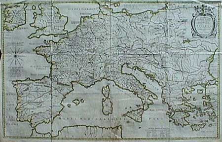
“Imperii Caroli Magni et vicinarum regionum Descriptio… Petro Bertio”
Map Maker:
Blaeu [Family]
Very large historical map (four sheets joined) dep... (full text available to subscribers)
| Item Detail |
| |
| |
MapMaker: |
Blaeu [Family]
|
|
| |
| |
Subject: |
Europe |
|
| |
Period/Size: |
1662 / 25.2" x 39.0" (64.0 x 99.1 cm)
|
|
| |
Color: |
Colored
|
|
| |
Condition: |
(B) Issued folded, now nicely pressed. Light tape stain near bottom fold with expert repair of tears. (condition help) |
|
| |
Source: |
|
|
| |
References: |
|
|
| |
|
|
| Sales Information |
| |
| |
Price: |
|
|
| |
| |
Offered by: |
Old World Auctions |
|
| |
Catalog: |
Auction No. 88 - Antique Maps, Charts, Atlases & Globes (160) |
|
| |
Lot/Item #: |
169 |
|
| |
| |
Date: |
10/1999
|
|
| |
| |
|
Antique Maps - Valuation and Pricing, Descriptions, Resources |
|
Home |
Information |
Search |
Register |
Contact Us |
Site Map
Americana Exchange, Inc. © 1999 - 2024 Americana Exchange, Inc.. All rights reserved.
OldMaps.com, the OldMaps.com logo and
AMPR are service marks or registered service marks of Americana Exchange, Inc..
|