Title:
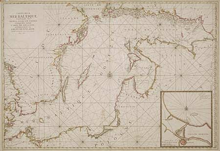
“Carte de la Mer Baltique Contenant les Bancs, Isles et Costes Comprises entre L' Isle de Zelande et l' Extrimité du Golfe de Finlande”
Map Maker:
Pierre Mortier
Handsome, large sea chart of the Baltic Sea with b... (full text available to subscribers)
| Item Detail |
| |
| |
MapMaker: |
Pierre Mortier
|
|
| |
| |
Subject: |
Baltic |
|
| |
Period/Size: |
1693 / 23.5" x 34.5" (59.7 x 87.7 cm)
|
|
| |
Color: |
Colored
|
|
| |
Condition: |
(B) Water stains in margins, old repairs on fold, which should be redone. (condition help) |
|
| |
Source: |
|
|
| |
References: |
|
|
| |
|
|
| Sales Information |
| |
| |
Price: |
|
|
| |
| |
Offered by: |
Old World Auctions |
|
| |
Catalog: |
Auction No. 94 - Antique Maps, Charts, Atlases & Globes (166) |
|
| |
Lot/Item #: |
265 |
|
| |
| |
Date: |
03/2001
|
|
| |
| |
|
Antique Maps - Valuation and Pricing, Descriptions, Resources |
|
Home |
Information |
Search |
Register |
Contact Us |
Site Map
Americana Exchange, Inc. © 1999 - 2024 Americana Exchange, Inc.. All rights reserved.
OldMaps.com, the OldMaps.com logo and
AMPR are service marks or registered service marks of Americana Exchange, Inc..
|