Title:
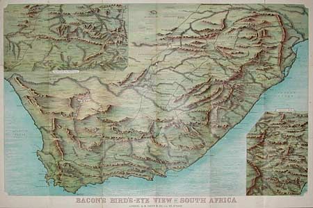
“Bacon's Bird's-Eye View of South Africa with enlarged views of Natal, and Mafeking to Pretoria”
Map Maker:
George Washington Bacon & Company
Color lithographed fold-out map of South Africa in... (full text available to subscribers)
| Item Detail |
| |
| |
MapMaker: |
George Washington Bacon & Company
|
|
| |
| |
Subject: |
South Africa |
|
| |
Period/Size: |
1899 / 24.0" x 38.0" (61.0 x 96.6 cm)
|
|
| |
Color: |
Colored
|
|
| |
Condition: |
(B) Some splits along the folds, map bright. (condition help) |
|
| |
Source: |
|
|
| |
References: |
|
|
| |
|
|
| Sales Information |
| |
| |
Price: |
|
|
| |
| |
Offered by: |
Old World Auctions |
|
| |
Catalog: |
Auction No. 94 - Antique Maps, Charts, Atlases & Globes (166) |
|
| |
Lot/Item #: |
404 |
|
| |
| |
Date: |
03/2001
|
|
| |
| |
|
Antique Maps - Valuation and Pricing, Descriptions, Resources |
|
Home |
Information |
Search |
Register |
Contact Us |
Site Map
Americana Exchange, Inc. © 1999 - 2024 Americana Exchange, Inc.. All rights reserved.
OldMaps.com, the OldMaps.com logo and
AMPR are service marks or registered service marks of Americana Exchange, Inc..
|