Title:
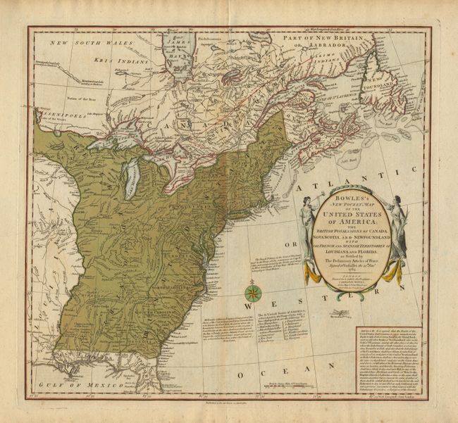
“Bowles's New Pocket Map of the United States of America; the British possessions of Canada, Nova Scotia and Newfoundland with the French and Spanish Territories of Louisiana and Florida as Settled by The Preliminary Articles of Peace, Signed at Versailles”
Map Maker:
Carington Bowles
A striking map of the United States issued shortly... (full text available to subscribers)
| Item Detail |
| |
| |
MapMaker: |
Carington Bowles
|
|
| |
| |
Subject: |
United States and Canada |
|
| |
Period/Size: |
1784 / 18.5" x 20.0" (47.0 x 50.8 cm)
|
|
| |
Color: |
Colored
|
|
| |
Condition: |
(B) Original color with some browning along centerfold and linen tape repair on split in bottom margin fold, else very good. (condition help) |
|
| |
Source: |
|
|
| |
References: |
|
|
| |
|
|
| Sales Information |
| |
| |
Price: |
|
|
| |
| |
Offered by: |
Old World Auctions |
|
| |
Catalog: |
Auction No. 95 - Antique Maps, Charts, Atlases & Globes (167) |
|
| |
Lot/Item #: |
101 |
|
| |
| |
Date: |
06/2001
|
|
| |
| |
|
Antique Maps - Valuation and Pricing, Descriptions, Resources |
|
Home |
Information |
Search |
Register |
Contact Us |
Site Map
Americana Exchange, Inc. © 1999 - 2024 Americana Exchange, Inc.. All rights reserved.
OldMaps.com, the OldMaps.com logo and
AMPR are service marks or registered service marks of Americana Exchange, Inc..
|