Title:
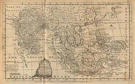
“An Accurate Map of the East Indies, in which ye European Forts, Factories, and Settlements are inserted & distinguished”
Map Maker:
Emanuel Bowen
Good detail of the region from India to New Guinea... (full text available to subscribers)
| Item Detail |
| |
| |
MapMaker: |
Emanuel Bowen
|
|
| |
| |
Subject: |
South East Asia |
|
| |
Period/Size: |
1757 / 7.1" x 11.5" (18.1 x 29.3 cm)
|
|
| |
Color: |
Black & White
|
|
| |
Condition: |
(B) Toned with short tear at top margin, closed with archival tape. (condition help) |
|
| |
Source: |
Gentleman's Magazine |
|
| |
References: |
Jolly GENT-62 & GENT-79. |
|
| |
|
|
| Sales Information |
| |
| |
Price: |
|
|
| |
| |
Offered by: |
Old World Auctions |
|
| |
Catalog: |
Auction No. 95 - Antique Maps, Charts, Atlases & Globes (167) |
|
| |
Lot/Item #: |
328 |
|
| |
| |
Date: |
06/2001
|
|
| |
| |
|
Antique Maps - Valuation and Pricing, Descriptions, Resources |
|
Home |
Information |
Search |
Register |
Contact Us |
Site Map
Americana Exchange, Inc. © 1999 - 2024 Americana Exchange, Inc.. All rights reserved.
OldMaps.com, the OldMaps.com logo and
AMPR are service marks or registered service marks of Americana Exchange, Inc..
|