Title:
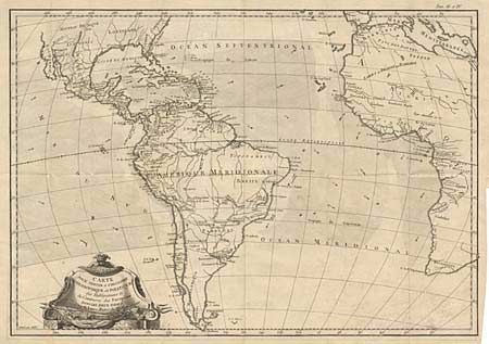
“Carte pour servir a l'Histoire Philosophique et Politique des Etablissemens et du Commerce des Européens dans les deux Indes”
Map Maker:
Rigobert Bonne
Cleaning engraved map shows South American, most o... (full text available to subscribers)
| Item Detail |
| |
| |
MapMaker: |
Rigobert Bonne
|
|
| |
| |
Subject: |
Atlantic |
|
| |
Period/Size: |
1780 / 12.7" x 18.2" (32.3 x 46.3 cm)
|
|
| |
Color: |
Black & White
|
|
| |
Condition: |
(A) ome light offsetting, still very good. (condition help) |
|
| |
Source: |
|
|
| |
References: |
|
|
| |
|
|
| Sales Information |
| |
| |
Price: |
|
|
| |
| |
Offered by: |
Old World Auctions |
|
| |
Catalog: |
Auction No. 95 - Antique Maps, Charts, Atlases & Globes (167) |
|
| |
Lot/Item #: |
220 |
|
| |
| |
Date: |
06/2001
|
|
| |
| |
|
Antique Maps - Valuation and Pricing, Descriptions, Resources |
|
Home |
Information |
Search |
Register |
Contact Us |
Site Map
Americana Exchange, Inc. © 1999 - 2024 Americana Exchange, Inc.. All rights reserved.
OldMaps.com, the OldMaps.com logo and
AMPR are service marks or registered service marks of Americana Exchange, Inc..
|