Title:
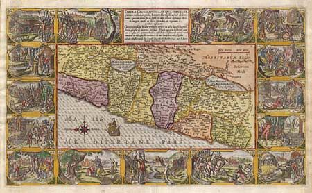
“Tabula Geographica, In Qua Omnes Regiones, urbes, oppida, loca et fluvij Israeliae descri..”
Map Maker:
Petrus Plancius
A supremely graphic map from a Dutch Bible depicti... (full text available to subscribers)
| Item Detail |
| |
| |
MapMaker: |
Petrus Plancius
|
|
| |
| |
Subject: |
Holy Land |
|
| |
Period/Size: |
1620 / 11.5" x 19.5" (29.3 x 49.6 cm)
|
|
| |
Color: |
Colored
|
|
| |
Condition: |
(A) Expert extension of side margins with superb facsimile of between 1/8" and 1/4" of engraving. (condition help) |
|
| |
Source: |
|
|
| |
References: |
|
|
| |
|
|
| Sales Information |
| |
| |
Price: |
|
|
| |
| |
Offered by: |
Old World Auctions |
|
| |
Catalog: |
Auction No. 95 - Antique Maps, Charts, Atlases & Globes (167) |
|
| |
Lot/Item #: |
287 |
|
| |
| |
Date: |
06/2001
|
|
| |
| |
|
Antique Maps - Valuation and Pricing, Descriptions, Resources |
|
Home |
Information |
Search |
Register |
Contact Us |
Site Map
Americana Exchange, Inc. © 1999 - 2024 Americana Exchange, Inc.. All rights reserved.
OldMaps.com, the OldMaps.com logo and
AMPR are service marks or registered service marks of Americana Exchange, Inc..
|