Title:
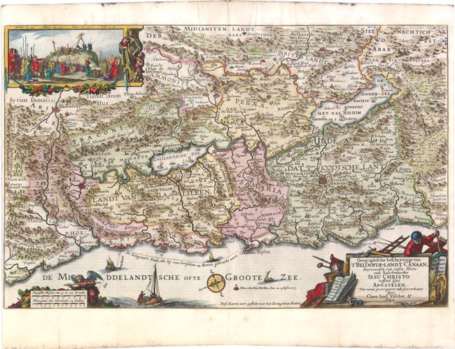
“Geographische Beschryvinge van t'Beloofde-Landt Canaan…”
Map Maker:
Claes Janszoon Visscher
This is a fine Bible map of the Holy Land with nor... (full text available to subscribers)
| Item Detail |
| |
| |
MapMaker: |
Claes Janszoon Visscher
|
|
| |
| |
Subject: |
Holy Land |
|
| |
Period/Size: |
1642 / 12.0" x 19.0" (30.5 x 48.3 cm)
|
|
| |
Color: |
Colored
|
|
| |
Condition: |
There are narrow side margins which is common with Dutch bible maps. There is a small edge tear in the lower blank margin that does not enter the image and some minor ink stains in the upper blank margin. (condition help) |
|
| |
Source: |
|
|
| |
References: |
Laor #789; Poortman & Augusteijn #88. |
|
| |
|
|
| Sales Information |
| |
| |
Price: |
|
|
| |
| |
Offered by: |
Old World Auctions |
|
| |
Catalog: |
Auction No. 138 - Antique Maps, Charts, Atlases & Globes (7409) |
|
| |
Lot/Item #: |
723 |
|
| |
| |
Date: |
12/2011
|
|
| |
| |
|
Antique Maps - Valuation and Pricing, Descriptions, Resources |
|
Home |
Information |
Search |
Register |
Contact Us |
Site Map
Americana Exchange, Inc. © 1999 - 2024 Americana Exchange, Inc.. All rights reserved.
OldMaps.com, the OldMaps.com logo and
AMPR are service marks or registered service marks of Americana Exchange, Inc..
|