Title:
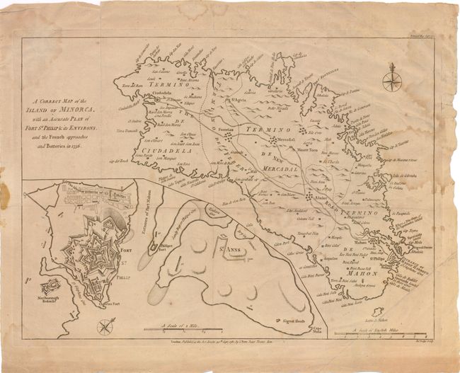
“A Correct Map of the Island of Minorca, with an Accurate Plan of Fort St. Phillip & its Environs, and the French Approaches and Batteries in 1756”
Map Maker:
John Bew
This detailed map of Minorca, one of the Balearic ... (full text available to subscribers)
| Item Detail |
| |
| |
MapMaker: |
John Bew
|
|
| |
| |
Subject: |
Minorca, Spain |
|
| |
Period/Size: |
1781 / 10.8" x 14.5" (27.5 x 36.9 cm)
|
|
| |
Color: |
Black & White
|
|
| |
Condition: |
There is some scattered damp staining and occasional small spots with an extraneous crease at lower right. Issued folding and now flat. (condition help) |
|
| |
Source: |
Political Magazine |
|
| |
References: |
Jolly #POL-33. |
|
| |
|
|
| Sales Information |
| |
| |
Price: |
|
|
| |
| |
Offered by: |
Old World Auctions |
|
| |
Catalog: |
Auction No. 138 - Antique Maps, Charts, Atlases & Globes (7409) |
|
| |
Lot/Item #: |
590 |
|
| |
| |
Date: |
12/2011
|
|
| |
| |
|
Antique Maps - Valuation and Pricing, Descriptions, Resources |
|
Home |
Information |
Search |
Register |
Contact Us |
Site Map
Americana Exchange, Inc. © 1999 - 2024 Americana Exchange, Inc.. All rights reserved.
OldMaps.com, the OldMaps.com logo and
AMPR are service marks or registered service marks of Americana Exchange, Inc..
|