Title:
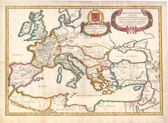
“La Carte des Conciles / Tabula Geographica Locorum ubi Habita sunt Concilia tam Generalia quam Provincialia, Synodi et Conciliabula”
Map Maker:
Pierre Duval
This religious-historical map of Europe extends to... (full text available to subscribers)
| Item Detail |
| |
| |
MapMaker: |
Pierre Duval
|
|
| |
| |
Subject: |
Europe |
|
| |
Period/Size: |
1660 / 14.8" x 21.3" (37.6 x 54.1 cm)
|
|
| |
Color: |
Colored
|
|
| |
Condition: |
Attractive color on watermarked paper with light-uneven toning and marginal soiling. Minor tears just entering border at left and at top have been professionally repaired. (condition help) |
|
| |
Source: |
|
|
| |
References: |
|
|
| |
|
|
| Sales Information |
| |
| |
Price: |
|
|
| |
| |
Offered by: |
Old World Auctions |
|
| |
Catalog: |
Auction No. 138 - Antique Maps, Charts, Atlases & Globes (7409) |
|
| |
Lot/Item #: |
464 |
|
| |
| |
Date: |
12/2011
|
|
| |
| |
|
Antique Maps - Valuation and Pricing, Descriptions, Resources |
|
Home |
Information |
Search |
Register |
Contact Us |
Site Map
Americana Exchange, Inc. © 1999 - 2024 Americana Exchange, Inc.. All rights reserved.
OldMaps.com, the OldMaps.com logo and
AMPR are service marks or registered service marks of Americana Exchange, Inc..
|