Title:
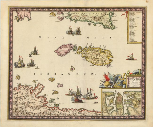
“Insula Malta Accuratissime Delineata, Urbibus, et Fortalitiis”
Map Maker:
Frederick de Wit
This superb map shows the strategic location of Ma... (full text available to subscribers)
| Item Detail |
| |
| |
MapMaker: |
Frederick de Wit
|
|
| |
| |
Subject: |
Malta |
|
| |
Period/Size: |
1680 / 17.5" x 21.3" (44.5 x 54.1 cm)
|
|
| |
Color: |
Colored
|
|
| |
Condition: |
Lovely color with minor centerfold separations that have been expertly repaired. There is an extraneous fold to the right of the centerfold, with minute loss of image along the southwest coastline of Malta. A tear through the lower-left corner of the ma (condition help) |
|
| |
Source: |
|
|
| |
References: |
|
|
| |
|
|
| Sales Information |
| |
| |
Price: |
|
|
| |
| |
Offered by: |
Old World Auctions |
|
| |
Catalog: |
Auction No. 138 - Antique Maps, Charts, Atlases & Globes (7409) |
|
| |
Lot/Item #: |
703 |
|
| |
| |
Date: |
12/2011
|
|
| |
| |
|
Antique Maps - Valuation and Pricing, Descriptions, Resources |
|
Home |
Information |
Search |
Register |
Contact Us |
Site Map
Americana Exchange, Inc. © 1999 - 2024 Americana Exchange, Inc.. All rights reserved.
OldMaps.com, the OldMaps.com logo and
AMPR are service marks or registered service marks of Americana Exchange, Inc..
|