Title:
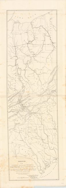
“Sketch of the Country Embracing Several Routes from Portsmouth Ohio, to Linville, N.C…”
Map Maker:
U.S. Corps of Engineers
This map details the country between Lake Erie sou... (full text available to subscribers)
| Item Detail |
| |
| |
MapMaker: |
U.S. Corps of Engineers
|
|
| |
| |
Subject: |
Mid-Atlantic United States |
|
| |
Period/Size: |
1832 / 12.3" x 41.0" (31.3 x 104.2 cm)
|
|
| |
Color: |
Black & White
|
|
| |
Condition: |
There is some light staining primarily near the title and along the edges in the blank margins. Issued folding. (condition help) |
|
| |
Source: |
|
|
| |
References: |
|
|
| |
|
|
| Sales Information |
| |
| |
Price: |
|
|
| |
| |
Offered by: |
Old World Auctions |
|
| |
Catalog: |
Auction No. 140 - Antique Maps, Charts, Atlases & Globes (9029) |
|
| |
Lot/Item #: |
166 |
|
| |
| |
Date: |
05/2012
|
|
| |
| |
|
Antique Maps - Valuation and Pricing, Descriptions, Resources |
|
Home |
Information |
Search |
Register |
Contact Us |
Site Map
Americana Exchange, Inc. © 1999 - 2024 Americana Exchange, Inc.. All rights reserved.
OldMaps.com, the OldMaps.com logo and
AMPR are service marks or registered service marks of Americana Exchange, Inc..
|