Title:
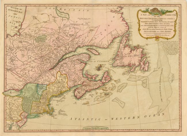
“A New and Correct Map of the British Colonies in North America Comprehending Eastern Canada with the Province of Quebec, New Brunswick, Nova Scotia, ... Newfoundland: with the Adjacent States of New England, Vermont, New York, Pennsylvania and New Jersey”
Map Maker:
Laurie & Whittle
This detailed map includes eastern Canada with Que... (full text available to subscribers)
| Item Detail |
| |
| |
MapMaker: |
Laurie & Whittle
|
|
| |
| |
Subject: |
Eastern Canada & United States |
|
| |
Period/Size: |
1794 / 18.5" x 25.8" (47.0 x 65.6 cm)
|
|
| |
Color: |
Colored
|
|
| |
Condition: |
A fine impression with offsetting and a couple of small abrasions. A few centerfold separations have been closed on verso with archival materials. (condition help) |
|
| |
Source: |
A New and Elegant Imperial Sheet Atlas |
|
| |
References: |
Stevens & Tree #65-c. |
|
| |
|
|
| Sales Information |
| |
| |
Price: |
|
|
| |
| |
Offered by: |
Old World Auctions |
|
| |
Catalog: |
Auction No. 140 - Antique Maps, Charts, Atlases & Globes (9029) |
|
| |
Lot/Item #: |
127 |
|
| |
| |
Date: |
05/2012
|
|
| |
| |
|
Antique Maps - Valuation and Pricing, Descriptions, Resources |
|
Home |
Information |
Search |
Register |
Contact Us |
Site Map
Americana Exchange, Inc. © 1999 - 2024 Americana Exchange, Inc.. All rights reserved.
OldMaps.com, the OldMaps.com logo and
AMPR are service marks or registered service marks of Americana Exchange, Inc..
|