Title:
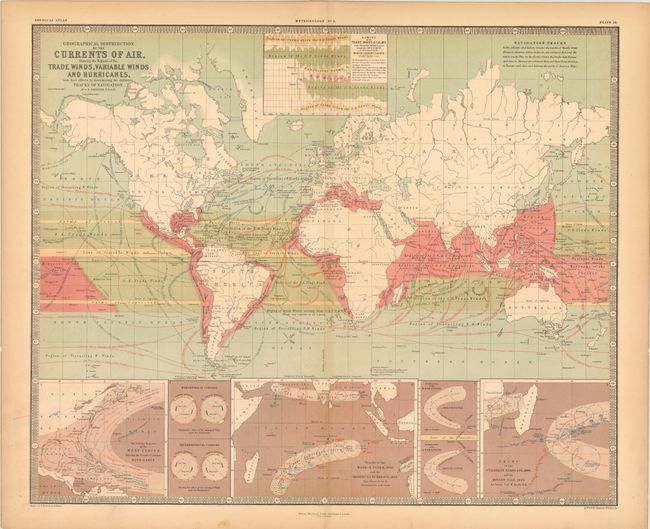
“Geographical Distribution of the Currents of Air, Showing the Regions of the Trade Winds, Variable Winds and Hurricanes, with their Effects in Determining the Different Tracks of Navigation”
Map Maker:
Alexander K. Johnston
Attractive thematic map from the English version o... (full text available to subscribers)
| Item Detail |
| |
| |
MapMaker: |
Alexander K. Johnston
|
|
| |
| |
Subject: |
World |
|
| |
Period/Size: |
1854 / 20.0" x 24.5" (50.8 x 62.3 cm)
|
|
| |
Color: |
Colored
|
|
| |
Condition: |
(B+ ) There are centerfold separations at top and bottom that extend 1.5" and 1" respectively past the neat line, with a hint of toning along the edges of the sheet. (condition help) |
|
| |
Source: |
The Physical Atlas of Natural Phenomena |
|
| |
References: |
|
|
| |
|
|
| Sales Information |
| |
| |
Price: |
|
|
| |
| |
Offered by: |
Old World Auctions |
|
| |
Catalog: |
Auction No. 141 - Antique Maps, Charts, Atlases & Globes (9037) |
|
| |
Lot/Item #: |
42 |
|
| |
| |
Date: |
09/2012
|
|
| |
| |
|
Antique Maps - Valuation and Pricing, Descriptions, Resources |
|
Home |
Information |
Search |
Register |
Contact Us |
Site Map
Americana Exchange, Inc. © 1999 - 2024 Americana Exchange, Inc.. All rights reserved.
OldMaps.com, the OldMaps.com logo and
AMPR are service marks or registered service marks of Americana Exchange, Inc..
|