Title:
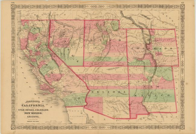
“Johnson's California, with Territories of Utah, Nevada, Colorado, New Mexico and Arizona”
Map Maker:
Johnson & Ward
This is the late 1863 - early 1864 edition in this... (full text available to subscribers)
| Item Detail |
| |
| |
MapMaker: |
Johnson & Ward
|
|
| |
| |
Subject: |
Southwestern United States |
|
| |
Period/Size: |
1863-64 / 15.5" x 22.0" (39.4 x 55.9 cm)
|
|
| |
Color: |
Colored
|
|
| |
Condition: |
(B+ ) Original color with light, pleasant toning. There is an archivally repaired centerfold separation at bottom that enters 2" into the map image, a few minor spots in the image, and a few edge tears confined to the blank margins. (condition help) |
|
| |
Source: |
Illustrated Family Atlas |
|
| |
References: |
|
|
| |
|
|
| Sales Information |
| |
| |
Price: |
|
|
| |
| |
Offered by: |
Old World Auctions |
|
| |
Catalog: |
Auction No. 141 - Antique Maps, Charts, Atlases & Globes (9037) |
|
| |
Lot/Item #: |
192 |
|
| |
| |
Date: |
09/2012
|
|
| |
| |
|
Antique Maps - Valuation and Pricing, Descriptions, Resources |
|
Home |
Information |
Search |
Register |
Contact Us |
Site Map
Americana Exchange, Inc. © 1999 - 2024 Americana Exchange, Inc.. All rights reserved.
OldMaps.com, the OldMaps.com logo and
AMPR are service marks or registered service marks of Americana Exchange, Inc..
|