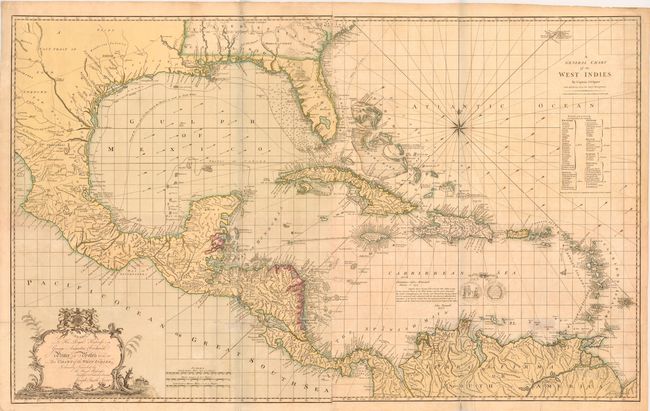
Title:
“A General Chart of the West Indies / To His Royal Highness George Augustus Frederick Prince of Wales &c. &c. &c. this Chart of the West Indies, is Humbly Inscribed…”
Map Maker:
Joseph Smith Speer
This impressive large-scale chart of the Gulf of M... (full text available to subscribers)
| Item Detail |
| |
| |
MapMaker: |
Joseph Smith Speer
|
|
| |
| |
Subject: |
Gulf of Mexico and Caribbean |
|
| |
Period/Size: |
1796 / 28.3" x 45.5" (71.9 x 115.6 cm)
|
|
| |
Color: |
Colored
|
|
| |
Condition: |
(B) Old color with light offsetting and a few faint damp stains. There are a few fold separations between the 11th and 12th parallels and in South America that were previously closed with cello tape, causing some discoloration. The cello tape has bee (condition help) |
|
| |
Source: |
|
|
| |
References: |
Sellers & Van Ee #1699. |
|
| |
|
|
| Sales Information |
| |
| |
Price: |
|
|
| |
| |
Offered by: |
Old World Auctions |
|
| |
Catalog: |
Auction No. 141 - Antique Maps, Charts, Atlases & Globes (9037) |
|
| |
Lot/Item #: |
304 |
|
| |
| |
Date: |
09/2012
|
|
| |
| |
|
Antique Maps - Valuation and Pricing, Descriptions, Resources |
|
Home |
Information |
Search |
Register |
Contact Us |
Site Map
Americana Exchange, Inc. © 1999 - 2024 Americana Exchange, Inc.. All rights reserved.
OldMaps.com, the OldMaps.com logo and
AMPR are service marks or registered service marks of Americana Exchange, Inc..
|