Rister or Sign In to see pricing information


Title:

Carte pour Servir a l'Histoire Philosophique et Politique des Etablissemens et du Commerce des Europeens Dans les Deux Indes…

Map Maker:

Rigobert Bonne

Carte pour Servir a l'Histoire Philosophique et Politique des Etablissemens et du Commerce des Europeens Dans les Deux Indes…

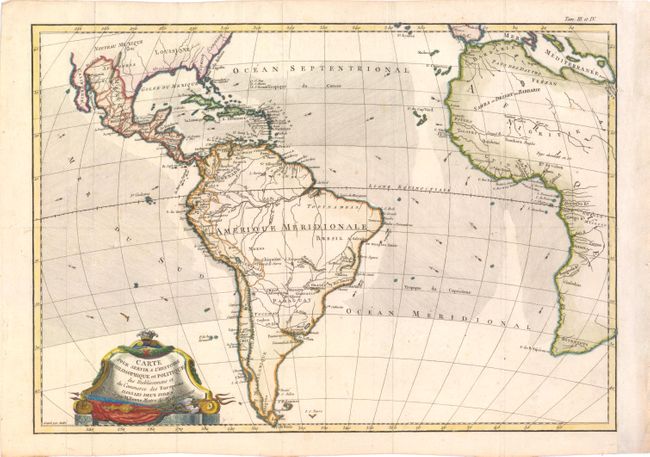
This chart is roughly centered on the Atlantic Oce... (full text available to subscribers)
Item Detail
 
  MapMaker:  

Rigobert Bonne


  Subject:  Atlantic Ocean & South America  
  Period/Size:  1775 / 12.5" x 18.0"  (31.8 x 45.8 cm)  
  Color:  Colored  
  Condition:  (B+ ) Issued folding, now pressed, on watermarked paper with a few minor spots. Professionally remargined at right. (condition help)  
  Source:   
  References:   
 
 
Sales Information
 
  Price: 

Please register your email to view records, or sign in with email address to see records


  Offered by:  Old World Auctions  
  Catalog:  Auction No. 141 - Antique Maps, Charts, Atlases & Globes (9037)  
  Lot/Item #:  373  
 
  Date:  09/2012  


Antique Maps - Valuation and Pricing, Descriptions, Resources


Home | Information | Search | Register | Contact Us | Site Map

Americana Exchange, Inc. © 1999 - 2024 Americana Exchange, Inc.. All rights reserved. OldMaps.com, the OldMaps.com logo and
AMPR are service marks or registered service marks of Americana Exchange, Inc..