Title:
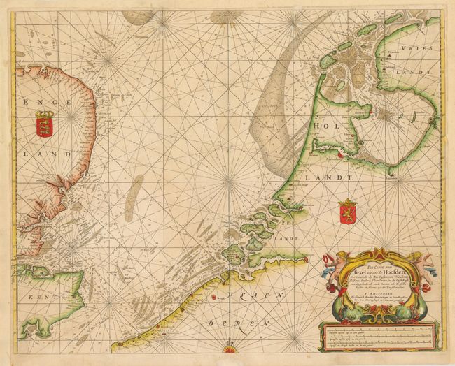
“Pas-Caert van Texel tot aen de Hoofden, Vertoonende de Zee-Custen van Vrieslant, Hollant, Zeelant, Vlaenderen, en de Oost Kust van Engeland, als mede Hoemen alle de Selve Kusten en Havens uyt der Zee sal Aendoen”
Map Maker:
Henrick Doncker
This detailed sea chart of the North Sea depicts t... (full text available to subscribers)
| Item Detail |
| |
| |
MapMaker: |
Henrick Doncker
|
|
| |
| |
Subject: |
Northwestern Europe |
|
| |
Period/Size: |
1660 / 16.6" x 21.0" (42.2 x 53.4 cm)
|
|
| |
Color: |
Colored
|
|
| |
Condition: |
(C+ ) There are archival repairs to some worm tracks at top, a long centerfold separation, and a few short tears that enter 0.5-1" into image. There are a few small abrasions on the sea monsters in title cartouche. Remargined at left, right and top. (condition help) |
|
| |
Source: |
|
|
| |
References: |
|
|
| |
|
|
| Sales Information |
| |
| |
Price: |
|
|
| |
| |
Offered by: |
Old World Auctions |
|
| |
Catalog: |
Auction No. 141 - Antique Maps, Charts, Atlases & Globes (9037) |
|
| |
Lot/Item #: |
448 |
|
| |
| |
Date: |
09/2012
|
|
| |
| |
|
Antique Maps - Valuation and Pricing, Descriptions, Resources |
|
Home |
Information |
Search |
Register |
Contact Us |
Site Map
Americana Exchange, Inc. © 1999 - 2024 Americana Exchange, Inc.. All rights reserved.
OldMaps.com, the OldMaps.com logo and
AMPR are service marks or registered service marks of Americana Exchange, Inc..
|