Rister or Sign In to see pricing information


Title:

Nieuwe Zee-Caart van de Propontis of Zee van Marmora, met de Twee Straaten Hellespont en't Naauw van Constantinopolen…

Map Maker:

Johannes van Keulen

Nieuwe Zee-Caart van de Propontis of Zee van Marmora, met de Twee Straaten Hellespont en't Naauw van Constantinopolen…

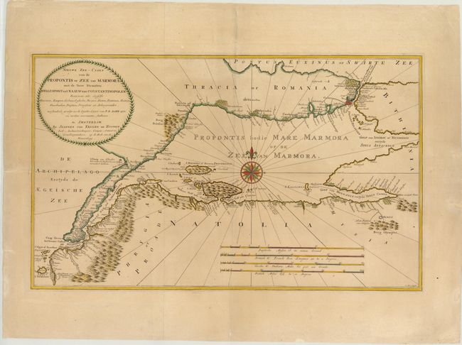
A rare map of the Sea of Marmara and surrounding r... (full text available to subscribers)
Item Detail
 
  MapMaker:  

Johannes van Keulen


  Subject:  Sea of Marmara, Turkey  
  Period/Size:  1770 / 15.6" x 26.0"  (39.7 x 66.1 cm)  
  Color:  Colored  
  Condition:  (B+ ) A nice impression on a sound sheet with wide margins. There are some minor edge tears, far from map, and a horizontal crease at left. (condition help)  
  Source:   
  References:   
 
 
Sales Information
 
  Price: 

Please register your email to view records, or sign in with email address to see records


  Offered by:  Old World Auctions  
  Catalog:  Auction No. 141 - Antique Maps, Charts, Atlases & Globes (9037)  
  Lot/Item #:  593  
 
  Date:  09/2012  


Antique Maps - Valuation and Pricing, Descriptions, Resources


Home | Information | Search | Register | Contact Us | Site Map

Americana Exchange, Inc. © 1999 - 2024 Americana Exchange, Inc.. All rights reserved. OldMaps.com, the OldMaps.com logo and
AMPR are service marks or registered service marks of Americana Exchange, Inc..